Tuesday, June 30, 2020

Green Tunnel, OR Trek then Burned Out---August--September 2006

Section B to F Ashland to McKenzie Highway—August-September 2006

On August 23, 2006, I returned to Pacific Crest Trail (PCT) at the intersection of I-5 and Highway 20. It has been about a year since my PCT quest to complete the Oregon section of the PCT ended with a sprained ankle.  I began this year’s quest by flying from Seattle to Medford, OR, followed by a night at the Best West Hotel in Ashland.  

On August 24, 2006, the hotel shuttle took me to the PCT trailhead some 10 miles south to the Highway 20 exit. I then walked under I-5 to connect with the PCT with Pilot Rock appearing in the distance. I found myself walking by several dirt roads and seeing several herds of cows and cowbells in this section of the PCT as I came up to Pilot Rock and continued on crossing one cow gate after another.


I ended the day at the Little Hyatt Reservoir campsite which even featured a toilet.  I hiked for about 9 1/2 hours and covered 22 miles with ascents of 3,440 ft and descents of 3,120 ft.

On August 25, 2006, I spent the day crossing logging roads and clear cuts including those surrounding Old Baldy with views to the south of Mt. Shasta. After hiking through private and Bureau of Land Management territory I finally entered the Rogue River National Forest with many to follow.


Just 200 yards off the PCT, I ended up the day at this 12’ square Brown Shelter cabin with nearby water well.  It was an 11-hour day of hiking and covered 22 miles with ascents of 2,640 ft and descents of 2,410 ft.

On August 26, 2006, I made my way past the west side of Brown Mountain through some basalt lava flows along the way until I got to Highway 140 near Fish Lake where I stayed for the night.  I only hiked 10 miles in 12 hours with ascents of 1,784 ft and descents of 1,803 ft.


It was like a hiker convention at the Fish Lake Resort with a bunch of thru-hikers, eating, showering, laundering, and eating again. Most had started mid-April from the south end of the PCT at Campo, CA, and had traveled some 1,776 trail miles to get here.  I too, ate, showered, laundered, and ate again.  Their trail names were On&On, Amoloyd, Lord Humongous, Last Cookie, and Lonesome Dave.


Section C. Fish Lake to North Boundary of Crater Lake National Park-Highway 138

On August 27, 2006, I began hiking through an area with many small lakes teeming with voracious mosquitos and hovering gnats.  I could not walk fast enough to keep them from attacking me. This was the first time I had to wear my mosquito headgear while hiking.  Before I put on the mosquito net, the gnats would just hover in front of my face, land on my glasses, or I would inhale them—Disgusting.  

Mt. McLaughlin was looming over the trail on the left and as I continued north, it would be a constant landmark as I made my way to the junction of the PCT and the Sky Lakes Trail.  I took the Sky Lakes Trail so I could enjoy the many lakes and ponds found along this 6-mile trail.


I ended my day at a campsite near a small pond and creek just before the Seven Lakes Trail junction. It was a 12-hour hike covering 26 miles with ascents of 2,550 ft. and descents of 2,103 ft.  Other than passing by numerous lakes and ponds, I was generally walking through a long green tunnel.

On, August 28, 2006, it was another day of hiking through the long green tunnel broken up by passing through some open saddles between Big Bunchgrass and Maude Mountain and Ethel Mountain and Lone Wolf Mountains.  

I then crossed over the Oregon Desert which is an area of pumice and ash covered by a lodgepole pine forest.  Beyond that, I entered the southern boundary of Crater Lake National Park and stayed near where the PCT cuts off to the “hikers PCT on the Dutton Creek Trail which would take me to the rim of Crater Lake and Lodge the following day passing the Watchman Peak.  

I hiked 26 miles in 12 hours. 


On August 29, 2006, I hiked up this steep  2 1/2 mile Dutton Creek Trail at about 7,700 ft elevation which was the highest point of my travels in both Oregon and Washington with the Watchman Peak nearby.  

I arrived at the rim of Crater Lake with smoke obscured views of Crater Lake with the Wizard Island. I was looking forward to having the popular breakfast brunch at the Crater Lake Lodge.  I met up with two thru-hikers—Beekeeper and Mark (no trail name yet) and treated them to the buffet breakfast.  I am sure the Lodge lost money on our breakfasts where we went for seconds and thirds of scrambled eggs, omelets, bacon, ham, fruit, fruit juice, coffee, and pastries.  


They were staying at the campground a couple miles below the rim and I continued north past the Watchman Peak.

Here is a view of the forest fire that is obscuring a clear view of Crater Lake.


The forest fire smoke was getting pretty thick as I made my way north of Crater Lake and rejoined the official PCT just below Grouse Hill. I ended my day near the North Border of Crater Lake National Park where it met Highway 138. I hiked 18 miles in 12 hours including the brunch break and sightseeing along the Rim. 

Section D. North Boundary of Crater Lake National Park to Willamette Pass

On August 30, 2006, the highlight of this day was the hike through a magical forest with most trees covered by these tumorous bulges along with dying trees that looked otherworldly.  These trees have been attacked by bark beetles causing this forest to die.  I walked for several miles through trees like these.  


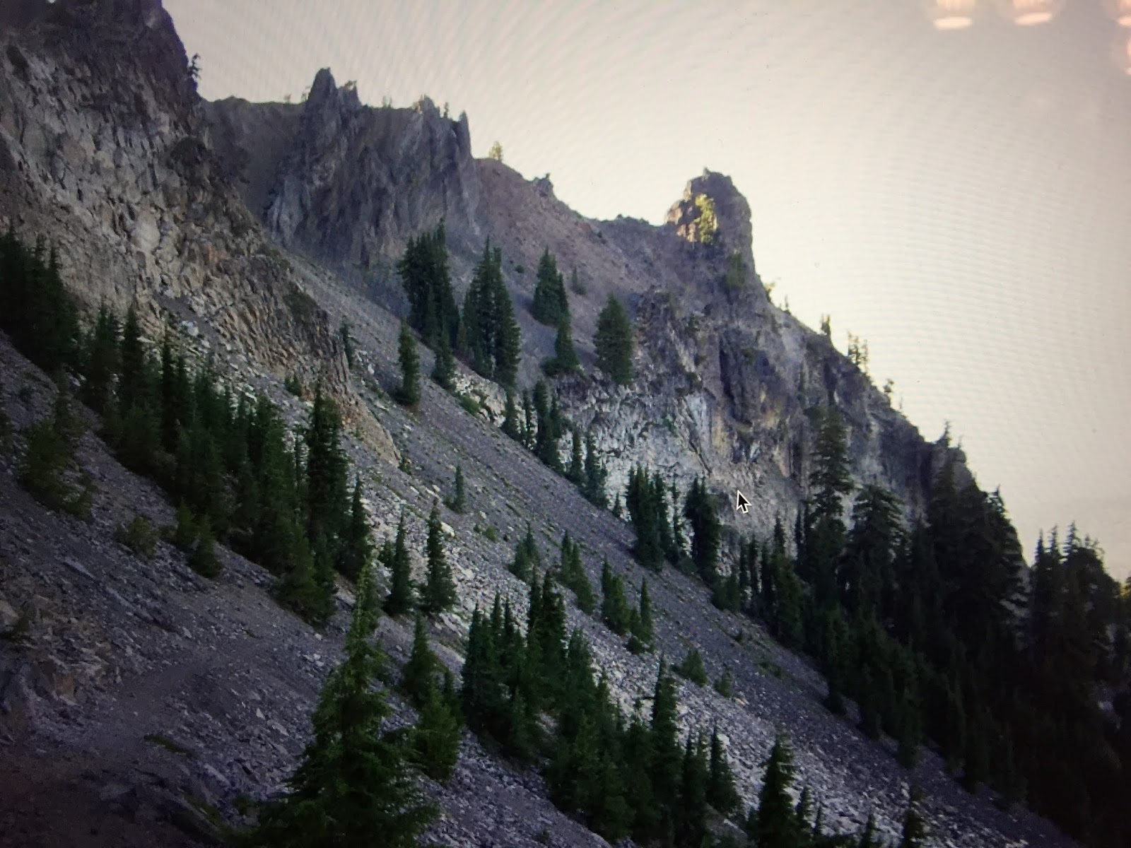
I then began my hike around the rugged Mt. Thielsen with an elevation of 9,182 ft. 


At the Thielsen Creek Trail, I met one other thru-hiker—Goodness— who was staying there.  I continued on and reached the official PCT highest elevation spot at an elevation of 7,560 ft.  


I continued on and had this view of Miller Lake to the south.


I ended the day at the Tolo Camp Springs after hiking for 14 hours and covering 26 miles.

On August 31, 2006, it was a 20-mile hiking day past Cowhorn Mountain and Summit Lake to where I found a campsite just below Mt. Yoran.  


On September 1, 2006, I hiked about 6 miles to the Shelter Cove Resort on Odell Lake for a shower—with the laundering of my clothes—and a full breakfast while wearing my rain pants and jacket as my clothes were drying.  


Section E Willamette Pass to McKenzie Pass-Highway 242

It was then on Willamette Pass where I enjoyed a big bacon cheese hamburger with a pint of Deschutes beer.  I finished up the day with a campsite by Charlton Lake.  Two other thru-hikers were also camped there: Osprey and Orca.  I hiked for a long 34 miles in 14 hours and arrived at 8:30 pm.

On September 2, 2006, I got off to a slow start at 8 AM and passed by the Charlton Butte just north of my campsite. I then began hiking through a burn area for the next half hour until I came to a string of lakes for most of the day along with the ever-present gnats and mosquitos. Again I had to wear my mosquito net to keep from getting stung or swallowing them while hiking.


I stopped by this small pond to get some water and found that in the grass and mud were hundreds of these tiny frogs. I made sure to filter them out of my water.


I took the short trail down to the Elk Lake Resort to resupply and stay the night.  The Resort store closed at 7pm and I did not arrive until 7:40 pm and would not open until 9am the following morning.  Fortunately, the shopkeeper opened up the store and also fed me some leftover spaghetti and meatballs.  After resupply and dinner, I headed back up to the trail that would rejoin the PCT and found a stealth camping spot for the night.  It was a 12-hour, 28-mile day.

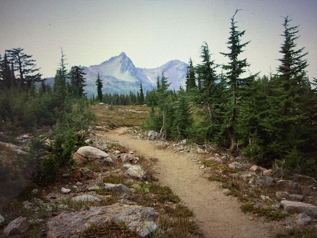
On September 3, 2006, the scenery began to change with more volcanic landscapes through the Three Sisters Wilderness Area.  I guess the pumice and ash underneath keep the vegetation from growing much so there were long stretches where I had good views of the South, Middle, and North Sisters.


The PCT wraps around a number of tarns, and creeks, and passes by Obsidian Falls.


More of the trail consisted of hiking along with some cinder cones and other lava flows.  It was a beautiful sunset just before I arrived at the Minnie Scott Springs campsite with its cold freshwater.  I hiked 24 miles in 12 hours.


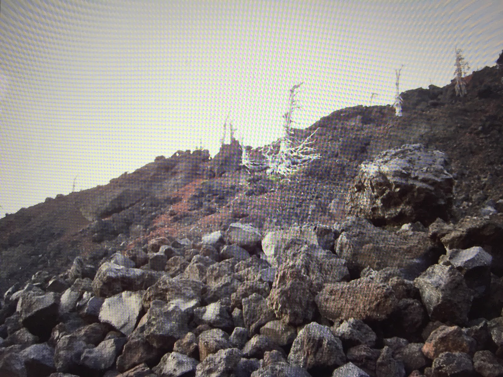
On September 4, 2006, I continued hiking through moonscape vistas of more lava flows as the trail twisted its way through the flows. I was looking forward to reaching McKenzie Pass on  Highway 242, just 5 more days until I completed the Oregon portion of the PCT at the Bridge of Gods, OR.

Again, the seven miles to McKenzie Pass passed through the big lava flows from the Yapoah Crater.  I recalled that astronauts used the lava flows found in Oregon for practice prior to going to the moon.  It was an out-of-this-world experience.


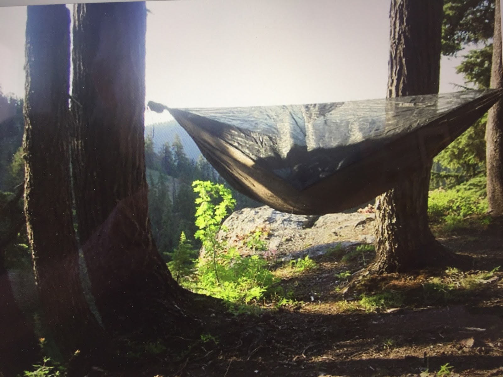
When I arrived at McKenzie, the PCT further north was closed because of forest fires so my PCT travels for 2006 were over.  What a disappointment.  I had plenty of food, my feet were feeling great, and my hammock shelter worked well in this forested portion of the PCT. 


From McKenzie Pass, I was able to hitch a ride from the third car that passed by, and he took me to the Eugene Amtrak station where I got an Amtrak to ride back to Seattle.
 

I have recently uploaded all of my travel videos to YouTube now that they allow longer uploads and you may want to see my travel adventures there.  That link is

 https://www.youtube.com/c/huntforgold.  


If you do go there, please subscribe to my video channel since it will help me eventually get some income there and help with my future travels. Fewer people are using DVDs so I am transitioning to streaming my travels on my YouTube channel.

Wednesday, June 17, 2020

Cruising PCT Oregon--It Crushed Me--July 2005

Section P Castle Crags to Etna Summit
I left Seattle on July 7, 2005, on the Amtrak Coast Starlight at about 10 am with a scheduled arrival in Dunsmuir, CA at 12:30 am, however, it did not get there until 5:30 am.  It turns out that freight trains get priority over Amtrak and we were on sideline rails as freight trains roared by.

Since the train was 5 hours late, I got some sleep on the train rather than a Dunsmuir hotel that I had planned to do.

On July 8,2005, I walked about 4 miles south of Dunsmuir to the Pacific Crest Trailhead (PCT) along Interstate 5.  From there, I hiked through the Castle Crags State Park  After that, I had a 2,500 climb as temperatures got up to the 90s.


During the hike, I met up with about 10 hikers, including a group of 6-day hikers.  I also met up with a Pacific Crest Trail Association—www.pcta.org—a work party of 8 who were clearing the trail of brush, and vegetation, leveling out, and broadening the trail.  They were supported by 2 mules and a horse that carried their food, camping gear, and work tools.  If you are interested in volunteering, just go to their website to look for work party opportunities. 


On the way up the trail, I was treated to glimpses of the Castle Crags and Mt. Shasta in the distance. It was a hot—97 degrees—steep hike to Frog Pond near the Soapstone trail at 6,500 ft.


It was a 12-hour hike of 18 miles with ascents of 5,080 ft and descents of 1,580 ft which included crossing several snowfields.

.
On July 9, 2005, fortunately, it was a cooler 50 to 70-degree day as I passed Porcupine Lake and then Toad Lake.


I continued on and took a break at the Upper Deadfall Lake where I met up with six people:  three hikers coming down from Willamette Pass, a couple fishing at Upper Deadfall Lake, and Robotic Man—a PCT thru-hiker. I then passed by Deadfall Lake just below the PCT.


I ended up the day at the Middle Fork of High Camp Creek at an elevation of 7,080 ft. where I had beef stroganoff after putting up my rain fly to stay dry since it rained all night.  It was an 11 1/2 hour hike of 24 miles with ascents of 3,430 ft and descents of 2,860 ft.


On July 10, 2005, after a cold, rainy night, I packed up and began hiking in 45-degree weather.  As the weather warmed up, I found myself on the wrong trail to Kangaroo Lake for about an hour before returning to the PCT because someone had switched the signage, and I failed to read the map at this intersection.  The views were great as were the fields of colorful wildflowers found along much of the trail.


It was another 11 1/2 hour hike of 24 miles with ascents of 3,000 ft. and descents of 3,460 ft. where I found the campsite at Mosquito Lake Creek at an elevation of 6,770 ft.  For dinner, I had lasagna and was pleased that my pack continued to get lighter.

On July 11, 2005, I got an early morning start after enjoying a crisp, clear night filled with clouds of stars of the Milky Way. Today I mostly hiked above the 7,000 ft level passing over saddles with spectacular views down long river valleys like these Cement Bluffs.  


I saw a group of 8 teenagers and their adult leader at a campsite near East Boulder Lake. They were the only people I saw that day.  I hiked a long 15 hours when I arrived at Payne Lake.  It was a 28-mile hike with huge ascents of 5,640 ft. and descents of 4,910 ft.

On July 12, 2005, shortly after I left Payne Lake, I had to get around two huge downed dead trees which made the trail impassable for equestrians.  I then passed by the cutoff to Etna Summit Village, a popular stopover for hikers with its hostel and popular ice cream parlor at the drugstore.  

Section Q Etna Summit to Seiad Valley
I continued on, and when I got to the Shelly Lake creek, I met up again with Robotic Man who had spent the night at Etna Summit and resupplied.  We hiked together a bit and then he continued on.

Shortly before stopping at Marten Lake, I met up with two Forest Service Sawyers—Trevor and Sean— carrying their bucksaw.  They told me they worked out of the Scott Ranger District and were clearing deadfalls along the PCT.  I told them of the two deadfalls I had to climb around.  In these designated Wilderness Areas, no chain saws or mechanized equipment can be used.  That is why they were using the bucksaw.


I usually like to stop for dinner before stopping at my campsite for the night.  That way I avoid having cooking smells around my campsite that tends to attract little critters like field mice, raccoons, or larger animals. 

I arrived at Angel Lake Saddle where I found a good location for my hammock setup.  It was a 15-hour hike of 23 miles with ascents of 4,390 ft and descents of 4,090 ft.

On July 13, 2005, I got a late start—7 AM—and the trail continued along with frequent ascents and descents on the way to the Marble Valley Guard Station where I met the two Forest Service volunteers, Sue and Hannah, who stayed here during the summer months.  They said they did some trail clearing and checked hiking permits as they did with me.


I later met up with a Forest Service Recreation Specialist, Togan, who was out scouting for places to send work parties to repair portions of the PCT.


When I got to the 2nd Footbridge—elevation of 6,840 ft.— at 9:30 pm, I had caught up with Robotic Man again who was already in his sleeping bag and tent. After a bit of talk and washing out my wind-shirt, we both went to sleep.  I had hiked 27 miles in 14 1/2 hours.

On July 14, 2005, Robotic Man and I had breakfast together. He headed out quickly before me so he could get to the Seiad Valley Post Office before it closed because he had mailed a “bounce box” to himself.  This is a common practice of resupplying yourself while on the trail.  Many thru-hikers using this approach would make up several boxes and have someone mail the boxes out to arrive in time for the hikers’ arrivals.

I headed out at about 6:30 AM and after a few more ups and downs, the trail entered the tree-lined trail all the way down to the Klamath River and Seiad Valley. It was a 4,400 ft descent in the last 13 1/2 miles.  After some road walking, the PCT met the Klamath River with Seiad Valley just across the river.  

I had another 3-mile road walk down to a bridge that crossed the Klamath River and then back to Seiad Valley.  I got there by noon, and on the valley floor, it was a sweltering 104 degrees.  From reading the Hiker Register at the Post Office, those who tried to wade across the River ended up regretting it—most of them slipped and fell and got everything wet.


I again met up with Robotic Man along with Cub, and her dog, Reba, at the Seiad Cafe next to the RV park that allows hikers to camp here.  This is the cafe that has the Pancake Challenge where you get the meal free if you can eat all of it in 2 hours—something like five 13 " diameter-sized, 1 2/" thick pancakes that weigh 9 lbs-- few hikers are successful, and if they are, they have their Polaroids posted on the wall. If you fail the challenge the meal costs you $16.  I wasn't up for this challenge since I am not fond of pancakes.

Here is a YouTube video of the Seiad Cafe Challenge


Robotic Man was finishing off a bacon cheeseburger with blackberry shake and watermelon when I arrived.

  
I had a five-egg sausage, cheese omelet with fried potatoes, and coffee.  I then went next door to the RV park and did my laundry—took my dirty clothes into the shower with me—and took two 3-minute showers.  That felt so good on this very hot day. I wore my rain pants and jacket while the clothes were drying.

The RV park had an area for PCT hikers complete with a refrigerator, TV, microwave, and hiker boxes.  One of the common complaints about using bounce boxes for resupply was that hikers would get tired of eating what they had planned.  In most hiker towns like Seiad Valley, there would be two hiker boxes: one for cast-off equipment and supplies, and one for unwanted food—fruit leather, couscous, and corn pasta were frequent castoffs.  

While waiting for my clothes to dry in the hot weather, I used a 5 lb priority mailbox to fill it up with things I found I had not used nor needed and shipped it home.  I had a couple of beers while talking to Cub, who was a recent graduate of San Francisco State.  She was staying at the RV park for the night.  I had decided to hike up after 5 pm when it was cooling off to the mid-90s.

Before leaving, I had Dave, the cafe cook, make me a bacon cheeseburger along with a root beer float.  After several days on the PCT eating camp food, most hikers, including me, have voracious appetites when they arrive in trail towns.

First, I did some more road walking before the PCT started up 4,400 more feet to Devils Peak saddle.  After 4 hours of climbing up, it got dark, the trail was overgrown, and it was difficult to find the springs the guidebook had mentioned.  Around 9 pm it was still 87 degrees and I finally found the spring, and it was just a dribble that took me 10 minutes to fill my liter bottle.  I used the Aqua Mira to purify the water—it takes 5 minutes to mix the two chemicals and another 20 minutes after adding the mixture to the liter bottle before it is purified.  It was tasty though--well worth the wait after such a hot, brushy climb.

I continued on to the next listed spring, but I couldn't find it in the dark, so I decided to set up camp.  Unfortunately, there were no nearby trees so I just slept on the ground--called cowboy camping-- for the night and wore my head mosquito net.

On July 15, 2005, I woke up and quickly found the spring I had failed to find in the dark. I enjoyed the cooler temperature at these higher elevations. Once past Upper Devils Peak, I hiked along the crest until I came to the Kangaroo Springs area where the meadows and bare trees were the remains of an old forest fire that opened up views.


Shortly afterward, I came to the small Lily Pad Lake with Red Butte looming above with the PCT crossing by the lake in the middle of this picture.


Once again, the PCT crossed several dirt roads which led to old mining camps. I took one of the spur roads about 1/4 mile to Alex Hole Camp, with a nearby spring, to spend the night.  I lashed my hammock between two trees that were on the edge of this steep cliff.  I just had to remember when I got out of the hammock, not to get out on the cliffside.  Alex Hole Camp was the best campsite for this year’s PCT adventure. I hiked about 21 miles in 11 hours and the elevation was 6,600 ft.


On July 16, 2005, I started out with plans to hike to Grouse Gap for the night some 26 miles away.  The first highlight on this day was crossing the California/Oregon border after hiking 10 miles.  


I thought that this was going to be my year to do the entire Oregon section of the PCT.  It was not to be.  When I got to Grouse Gap, I decided to press on to Ashland to get a huge meal. My mind was on steak, corn on the cob, salad, a few pints of beer, and strawberry-rhubarb pie. It would be another 11 miles to I-5 where I would hitchhike into Ashland.  

I passed through open meadows near the Mt. Ashland Ski Area as well as an old burn area with dead snags.


I started to jog down through the meadows while wearing dark glasses, and unfortunately, when I went into a grove of trees, I did not see a fallen limb of a tree on the trail. I tripped and ended up with a sprained or broken left ankle.  

This where the PCT Oregon CRUSHED me.


With 10 miles to go, I knew I would not be able to get my shoe on again if I took it off.  I loosened my shoe and wrapped it with my bandana and vet wrap.  Every time I came across a cold creek, I soaked my ankle. I was so glad I had my trekking poles to help me along the trail. 

It was getting dark when I got to the I-5 frontage road, and I waved down the first car fortunately, two guys in a car stopped for me and drove me to the hospital.

It turned out to be a sprain, so they wrapped it up and gave me crutches and pain pills.  I then took a taxi to a nearby Best Western Hotel where I figured out that driving a rental car home would be easier than going to the Medford Airport.  Luckily it was my left foot so I had no problem driving home.  Since I had Annual Travelguard Insurance, Travelguard reimbursed me for the hospital, taxi, and rental car home, but not the hotel.

A few months of Physical Therapy got me walking better than before since the physical therapist, Rim, taught me how to walk with less pronation. 

My PCT plan for 2006, was to complete the Oregon section of the PCT from Ashland to Bridge of the Gods.

I have recently uploaded all of my travel videos to YouTube now that they allow longer uploads and you may want to see my travel adventures there.  That link is

 https://www.youtube.com/c/huntforgold.  


If you do go there, please subscribe to my video channel since it will help me eventually get some income there and help with my future travels. Fewer people are using DVDs so I am transitioning to streaming my travels on my YouTube channel.