Section A. Mexican Border to Warner Springs
On May 22, 2007, I took an early morning Alaska Air flight from Seattle to San Diego. I was met by my cousin, Craig Short, who lived in National City, CA, who drove me to the start of the Pacific Crest Trail (PCT) at Campo, CA, about 60 miles away. After a few pictures, I began my northward journey around 2 pm.


Me

Craig

Most thru-hikers—hikers who complete the PCT in one season—begin around mid-April with the expectation that the snow levels have lowered enough to safely navigate the route, especially when crossing Forester Pass at an elevation of 13,113 ft., and high river crossings from the melting snows.
Most of the hikers I encountered were section hikers like me or day hikers.
On my first day hiking I came across a rattlesnake I had almost stepped on if it hadn’t rattled at me. This was the first of five rattlesnakes I encountered in Southern California and the entire PCT. Every time their sudden rattle made me jump in surprise and fear.

While hiking along a gully in Hauser Creek a flock of wild turkeys surrounded me—squawking and flapping about.
I had wanted to get to Lake Morena some 19 miles from the border, but it was getting dark around 9 pm and it was a 1,000 ft climb to the lake. I cowboy camped along Hauser Creek after 16 miles in 7 hours with an ascent of 1,759 ft. and descent of 2,358 ft.

On May 23rd, I continued to Lake Morena Campground where I had breakfast. The area is mostly low shrubs with occasional trees near water sources. The PCT took me under the I-94 freeway and later passed between some of these rusty rock formations made of gneiss nearby Cameron Valley. The open lands with just low bushes including cholla, ocotillo, chaparral, and sagebrush would give me a taste of what it would be like when I crossed the Mojave Desert to the north.


I made it to the Burnt Rancheria campground by 9:30 pm after hiking for 25 miles in 15 hours with ascents of 6,129 ft. and descents of 2,707 ft.
On May 24th, as I was still in my sleeping bag, a group of three immigrants carrying just gallon jugs of water stopped on their journey for employment in the US and to refill their jugs. I wished them “buena suerte hombres para encontrar trabajo”. They laughed at my funny Spanish.

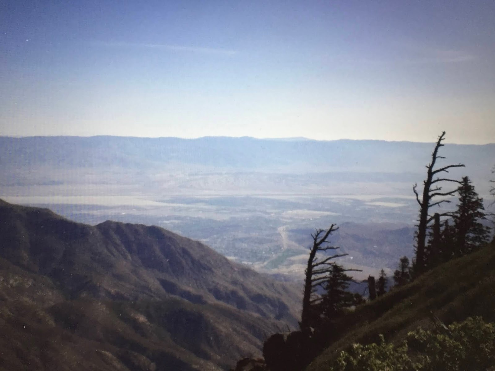
It was a short hike to Mt. Laguna where many hikers detoured to the nearby store. I continued hiking instead taking in the views down the valleys and across to the mountains to the north. I was again surprised by the rattle of a snake where I had just put my hand.
I ended my day at 9 pm along the trail on Granite Mountain by cowboy camping after 15 hours and 19 miles with ascents of 6,250 ft and descents for 3,565 ft.

On May 25th, the wind began picking up, and fortunately while heading north it aided me, but when I took a switchback to the south, I had to lean into the strong winds to keep from falling over. Lots of great views of the Vallecito Valley below where the Butterfield Overland Mail Station was located for stagecoaches that ran from St. Louis to California.
The trail skirts along the Oriflamme Canyon and along the way, I came across this welcomed water cache supplied by the ADZPCTKOP—short for the Annual Day Zero Pacific Crest Trail Kick-Off Party, which annually was organized by former thru-hikers at Lake Morena around mid-April to help the new season thru-hiker wannabes. It was last held in 2017 because it got too large and concentrated too large a group of hikers starting off all at the same time.


I ended the day around 9 pm at the Barrel Springs campsite where I got water from the horse trough and bedded down in the surrounding oak trees. During the night, I was serenaded by a family of coyotes. I hiked 29 miles in 11 hours with ascents of 3,428 ft and descents of 3,448 ft.
On May 26th, I was looking forward to getting into Warner Springs, but first I had to hike just 8 miles across sandy sagebrush flats, dodging the cattle grazing there. It was a 5-hour hike with ascents of 1,027 ft. and descents of 1,394 ft.
As I came into Warner Springs at about 10 am, I headed directly to the Warner Springs Ranch Resort where I got a small room and enjoyed a hot shower. They give thru-hikers old towels to use because thru-hikers are so dirty.
After that, I had a big lunch in the restaurant and then enjoyed the hot mineral springs and swimming pool. It was a good treat for covering the first 100 miles of the PCT. This was also an overnight stop for the Butterfield Stage Line and Kit Carson stayed here in 1846 on the site of the Cupeño Native American village.

Section B Warner Springs to San Gorgonio Pass
On May 27th, I first enjoyed a big buffet breakfast at the Resort, resupplied, and then hiked along the Agua Caliente Creek which has dried up, but I enjoyed the shade of the trees along the creek bed. It was then an ascent above the Chihuahua Valley until I came to Mike’s place, a Trail Angel, just off the trail on the Chihuahua Valley Road. It was a great break from the heat and strong winds of the day. He served up hamburgers, soft drinks, and lemonade under the shade of his front porch.

That break was enough to continue along the slopes of the Bucksnorts Mountains until I arrived at 9 pm at the Tule Springs campsite. The Pacific Crest Trail Association (PCTA) had installed a water tank and spigot as an all-season water source. It was a 14-hour hike of 27 miles with ascents of 4,327 ft. and descents of 3,8940 ft.
On May 28th, I came to another water cache after about 7 miles of hiking only to find no water. Good thing I had tanked up at Tule Springs. Water sources are often 20 to 30 miles apart and this was a reminder not to totally rely on these caches supplied by Trail Angels.


The highlight of the day was stopping at the Paradise Cafe near the crossing of Highway 74—Pines to Palms route to Palm Springs—to have their bacon cheeseburger and strawberry-rhubarb pie with bottomless cups of coffee.
San Jacinto Peak was my next destination by hiking up through the changing sagebrush and chaparral to scrub oaks, fir, cedar, and pines. It was also the first of two encounters with skunks blocking my trail. A bit of yelling and tossing rocks got the skunk to scurry away.
When I got to the Oak Springs for water, I found that the cattle had broken through the fencings and trashed the springs. I was able to get some water out and avoided the cow pie floaters and was glad my Aqua Mira chemicals purified this water.

I stopped for the night at Fobes Saddle after hiking for 16 hours and 30 miles with ascents of 6,424 ft and descents of 3,159. It was better hiking up the San Jacintos as it got cooler as night came.
On May 29th, the trail runs along steep valleys with a knife-edge trail north to Spitler and Apache Peaks with views of the Coachella Valley below.

I then took the Devil's Slide Trail down to the trail town of Idyllwood where I got a short hitch at the end of the trail to the center of town. It was just a 13-mile hike and I stayed at the Idyllwild Inn which catered to PCT hikers by giving out thru-hiker towels, a 10% PCT hikers discount, and a morning ride back up to the Devils Slide trailhead.

On May 30th, I got back up to the PCT thanks to a ride to the trailhead and a hike back up Devils Slide Trail to rejoin the PCT. The PCT goes up to about 9,000 past the San Jacinto Peak Trail which leads to the tram that overlooks Palm Springs. This was the highest point in this section followed by the lowest point when I hiked under the I-10 some 22 miles away.

The PCT now begins a descent along Fuller Ridge to my stealth campsite (not allowed-Palm Springs watershed)—but it was 10 pm and dark when I arrived and I left at daybreak— at Snow Canyon with the big water fountain at 1,727 ft. It was a 17-hour hike of 27 miles with ascents of 6,270 ft and descents of 9,770 ft.
On May 31st, I walked along the PCT in the shifting sands of the valley floor that were blazed with a series of PCT shields until I came to the underpass of the three bridges—Southern Pacific and two I-10—leaving the San Jacintos behind. After getting some resupplies at the mini-mart in San Gorgonio Pass area, I continued on to Whitewater among the fields of windmills. Notice how small these windmills are compared to the large ones that now prevail.


My next blog entry covers the rest of my 2007 PCT adventure starting with when I got lost for about six hours near Whitewater River and up to where I ended my 2007 season trek at the Vermillion Valley Resort 880 miles from the Mexican Border at Campo, CA.
Subscribe to My YouTube Channel
I have recently uploaded all of my travel videos to YouTube now that they allow longer uploads and you may want to see my travel adventures there. That link is
https://www.youtube.com/c/huntforgold.
If you do go there, please subscribe to my video channel since it will help me eventually get some income there and help with my future travels.
No comments:
Post a Comment